


ATTENTION Pilot should inform the handling agent 24 hours in advance so that they also schedule their services
Read more at point 12 https://www.aopa.gr/en/infosdetails.asp?NEWS_ID=1
This is a report composed for www.avsim.com during 1998 addressed to Flight Simulator pilots which has many facts true to real life aviation in Greece.
There is more to the image of the nice sunny beaches, summer resorts, mediteranean weather and 3500 years of civilisation when you think of flying in Greece. High mountaineous terrain emerging out of the sea, which surrounds the greatest part of this country’s area, mainly form Greece. That leaves little room for land planes that could accommodate regular ILS equipped airports that pilots would approach flying over calm valleys.
In the mainland, Peloponissos peninsula to the South and Makedonia to the North of Greece have lots of airports surrounded by steep mountains that require careful attention by the pilot during navigation, approach and departure procedures. Good examples are Athens Elefsis LGEL, Ioannina LGIO, Kastoria LGKA, Kalamata LGKL, Kozani LGKZ, Tripolis LGTP and Sparti LGSP. Usually you get adjacent lakes since these are the only land planes in the area.
In the Sea environment things get worse. The Ionian sea to the West and Eagean sea to the East contain dozens of islands which have every reason to accommodate an airport connecting them to the mainland. Some of them are classified as “remote” although you should be able to find nearby diversion fields. A quick look to runway lengths and airport lighting (and hours of operation in real life) will prove that with certain aircraft types and during nighttime lots of options are out of consideration. Strong North winds make approaches quite dangerous since from the open sea you end up approaching a runway near steep rising land formations that are not always favourable to the wind direction. Good examples are Samos LGSM, Kerkyra LGKR, Mikonos LGMK, Santorini LGSR, Mitilini LGMT, Leros LGLR, Ikaria LGIK (where "Icarus" fell in Greek Mythology !), Astypalaia LGPL, Chania LGSA, Iraklion LGIR, Kithira LGKC, Skiros LGSY and Syros LGSO.
Land formations
Since the mountains usually rise very close from the water to high elevations, tiny pieces of land are usually left for airports (and their approach paths). This problem creates one of the most challenging environments for pilots flying with anything from big jets to small props within the Mediterranean region.
You talk about hard approaches like Hong Kong Kai Tak or Innsbruck, Sion and Lugano in Europe? Why don’t you try to land in runway 09 of Samos LGSM, 36 of Skyros LGSO, 16 of Mikonos LGMK and 18 of Elefsis LGEL ? !!
In Kerkyra (Corfu) LGKR you get a runway constructed on landfilled area over water, oriented towards a mountain 7 Nm to the North and approach this runway by VORDME offset course due to another mountain to the West and while on short finals you have a hill just East of Rwy 35 threshold (one of the most famous planespoting balconies in Europe !).
The new Athens Venizelos LGAV is situated within the Mesogea valey East of Athens and Ymitos mountain with 4 CATII ILS 4000m long Runways. One of the phenomenoes already observed in it's few months of operation, since April 2001, is wind direction shift when on ILS 03L (most frequent). With NorthEasterly winds Ymitos mountain, to the West, creates SouthEasterly winds at LGAT area. During initial approach on LGAV 03L pilots report strong tailwinds which at final approach stage change to headwinds. This is simulated in FS environment if you appr
Unofficial – please consult appropriate sources prior to flight
Airport data:
Elevation: 12’
Runway: 08R-26L 1205x38m asphalt
Circuits 1000’ MSL on south side, 08R – right hand, 26L – left hand
Navaid: NDB ‘MGR’ 405 KHz on field
HCAA: Tel. +30-22960-21540 <TD height=14 THE AIRFIELD DISCONTINUED OPERATIONS IN 2012 - YOU CAN NOT LAND THERE The runway is often used for Drag car races with objects permanently placed inside the runway. Ikaros general aviation airfield 105km Northwest of Athens Greece is situated in "Kopaida" area, west of Yliki lake. 102th Km Athens-Lamia Natl. Rd. -> Exit : "Aliartos - Akraifnio" -> Continue with "Ikaros" signs Flying to : ARP Location : N38 25 53 E023 08 07 Runway : 09-27 1000x23 m Elevation : 320 ft AVGAS : Available 7 days a week Name : Ikaros Operation hours : Daytime (SR-30, SS+30) & VFR conditions, 365 days / year Charges : 6 Euro per airport use CAUTION: Intense Ultralight activity to, from and above Kopaida landing grass strip 2~3 nm North of airfield. Ultralights often overfly Ikaros without radio contact at lower, higher or even exact Ikaros traffic pattern altitude. Ikaros Traffic patterns : South of airfield at 1500ft AMSL VHF Communications : Ikaros Unicom freq : 119.70 Weather: Most frequent wind direction : 030-050 at 5~10 Kts. Click here for current Tanagra LGTG AFB (nearest) weather station report Hellenic National Meteorological Service (Be patient ... it is slow) Nearby city of Halkida weather forecast from Yahoo http://weather.yahoo.com/forecast/GRXX0009.html For work enquiries at Ikaros contact : Mrs Maria Volioti at +30 6932 418068 Pictures Photographs provided by: Kyprianos Biris , Natalia Anemodoura Click on the images to view them in larger size.
Airport Phone Numbers
Fax: +30-22960-23601
Ikaros airfield
Ikaros airfield
Data
[last update : 09-Feb-2012]
Driving to :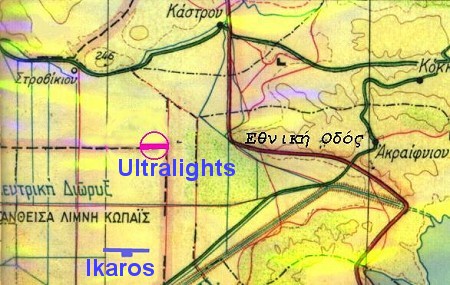
19Nm, track 289* from LGTG AFB
Airspace : Within Tanagra MTMA
ATZ : radius 3nm , 2000ft AGL
TORA: 1000m (09&27)
LDA : 840m (09&27)
2 Windsocks
GA aircraft parking spaces : 12 (tie downs)
Fuel : 100LL
Flight Plan code : ΖΖΖΖ (FPL remarks: "/DEP Ikaros, Kopaida" or "/DEST Ikaros, Kopaida")
Licenced, category : B2
Tanagra Approach : 120.25
Contact :
Owner : Airsafety Aviation SA
Email : ikarosairport@yahoo.gr , info@airsafety.gr ,
Website: http://www.airsafety.gr/
Caretaker : Call +30 6932 418071